 ultimate-guide
Pseudo-Satellite Persistent Surveillance Applications
Table of Contents
- What High-Altitude Pseudo-Satellites Are and How They Work
- Pseudo-Satellite vs Satellite: Key Differences in Coverage and Cost
- High-Altitude Pseudo-Satellite Applications Across Defense and Security
- Disaster Response and Environmental Monitoring With Persistent Coverage
- High-Altitude Pseudo-Satellite Endurance: Dwell Time and Mission Duration
- Pseudo-Satellite Surveillance Sensors and Payload Selection
- Operational Constraints and Reliability Challenges
- Privacy, Data Governance, and Regulatory Oversight
- Frequently Asked Questions
Last Updated: October 8, 2026
What High-Altitude Pseudo-Satellites Are and How They Work
A high-altitude pseudo-satellite, or HAPS, is an airborne platform designed to operate in the stratosphere at altitudes between 45,000 and 70,000 feet, providing persistent surveillance and communications coverage over a localized geographic area.
The fundamental appeal of pseudo-satellite persistent surveillance applications lies in their ability to hover indefinitely over a target area. A HAPS achieves this through a combination of solar power, lightweight materials, and station-keeping technologies that maintain altitude and position. The aircraft carries surveillance payloads such as imaging sensors, thermal cameras, and signal-collection equipment that continuously monitor the ground below.
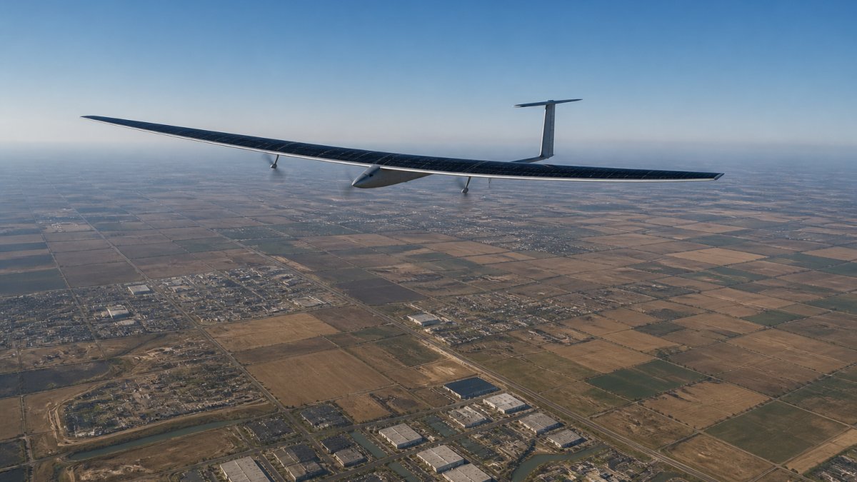
The operational model differs fundamentally from conventional satellites. Where a satellite passes over a target location every few hours or days, a pseudo-satellite can maintain dwell time, continuous observation, for weeks or months at a time. This extended presence enables real-time situational awareness and the ability to detect changes as they occur, rather than waiting for the next orbital pass.
Pseudo-Satellite vs Satellite: Key Differences in Coverage and Cost
The distinction between pseudo-satellite persistent surveillance and satellite-based Earth observation comes down to three critical factors: coverage footprint, dwell time, and operational economics. A satellite covers a global perspective but sacrifices continuous observation of any single location. A HAPS trades global reach for persistent, high-resolution monitoring of a specific region.
Satellites operate in fixed orbits that determine their revisit rate, the frequency at which they can image the same location. A typical Earth observation satellite might achieve revisit rates of 5 to 14 days for a given target. A pseudo-satellite can provide continuous observation, with dwell times measured in months rather than hours.
The cost structure also diverges sharply. Satellite systems require massive capital investment in launch vehicles, orbital infrastructure, and ground stations. A high-altitude pseudo-satellite platform, while technologically sophisticated, operates at a fraction of the cost because it avoids the expense of space launch and orbital mechanics. This cost advantage makes pseudo-satellite persistent surveillance applications accessible to agencies and organizations with regional rather than global priorities.
Coverage footprint size represents another key trade-off. A satellite covers hundreds of kilometers in a single pass. A HAPS typically covers a footprint of 100 to 200 kilometers in diameter, depending on altitude and sensor configuration.
High-Altitude Pseudo-Satellite Applications Across Defense and Security
Border security and reconnaissance
Border security agencies rely on persistent surveillance to detect unauthorized crossings, smuggling operations, and security threats. A pseudo-satellite stationed over a border region provides continuous monitoring that ground-based systems cannot achieve. The persistent surveillance capability allows operators to track movement patterns, identify trafficking corridors, and respond to incidents in real time.
The advantage over traditional border surveillance, towers, patrols, and stationary sensors, is the ability to maintain constant observation across hundreds of kilometers simultaneously. A HAPS can detect vehicle movement, gather intelligence on staging areas, and provide reconnaissance data that informs ground operations. The high-altitude position provides a vantage point that ground-based systems cannot match, while the persistent nature means no gaps in coverage due to weather, darkness, or operational constraints of human patrols.
Maritime patrol and anti-piracy operations
Maritime patrol represents one of the most operationally demanding applications for pseudo-satellite persistent surveillance. Naval and coast guard agencies use HAPS to monitor shipping lanes, detect piracy threats, and track illegal fishing operations across vast ocean areas. The persistent surveillance capability allows continuous monitoring of maritime traffic without requiring multiple aircraft or satellites.
Anti-piracy operations benefit from the real-time situational awareness that a hovering pseudo-satellite provides. When a vessel transmits a distress signal, operators can immediately assess the threat, track suspect vessels, and coordinate response assets. The extended dwell time means the platform remains on station for weeks, providing uninterrupted maritime domain awareness. This continuous presence is far more effective than satellite revisit rates or the limited flight duration of conventional maritime patrol aircraft.
Disaster Response and Environmental Monitoring With Persistent Coverage
Damage assessment and situational awareness
When disaster strikes, whether earthquake, hurricane, or flooding, rapid damage assessment is critical for emergency response coordination. A pseudo-satellite can be positioned over the disaster zone within hours, providing continuous imaging and thermal data that reveal the extent of damage, identify trapped populations, and guide resource allocation. The persistent surveillance allows operators to track the evolution of the disaster in real time, from initial impact through recovery phases.
Thermal imaging capabilities are particularly valuable in disaster response. A HAPS equipped with thermal sensors can detect heat signatures from fires, locate survivors in rubble, and monitor hazardous conditions that ground teams cannot safely assess. The combination of high-resolution imaging and thermal data creates a comprehensive situational picture that accelerates response decisions and saves lives.
Weather and oceanography monitoring
Environmental monitoring applications use the pseudo-satellite persistent surveillance model to track weather patterns, ocean conditions, and atmospheric phenomena. Meteorological agencies use HAPS to monitor storm development, track hurricane paths, and collect data on atmospheric conditions that improve forecast accuracy. The persistent presence allows continuous observation of weather systems as they evolve, rather than waiting for satellite overpasses.
Oceanography research benefits similarly. A pseudo-satellite can monitor sea surface temperature, ocean color, and wave conditions continuously, providing data that satellites can only sample periodically. This persistent observation enables better understanding of ocean dynamics and supports maritime safety operations that depend on accurate, current environmental data.
High-Altitude Pseudo-Satellite Endurance: Dwell Time and Mission Duration
The endurance of a pseudo-satellite, how long it can remain on station, is determined by power generation, propulsion efficiency, and maintenance requirements. Modern HAPS systems achieve mission durations measured in months, with some platforms designed for continuous operation across multiple seasons. This extended endurance is what fundamentally enables the persistent surveillance applications that define the technology.
Dwell time refers to the continuous observation period a HAPS can maintain over a target area. Where a satellite's dwell time for any specific location is measured in minutes per pass, a pseudo-satellite's dwell time is measured in weeks or months of uninterrupted coverage. This persistence transforms the operational value of surveillance data. Operators can detect subtle changes, track patterns over time, and establish baselines that enable anomaly detection, capabilities that are impossible with periodic satellite imagery.
The trade-off is that extended endurance requires significant investment in power systems, materials science, and autonomous flight control. A solar-powered HAPS must be lightweight enough to achieve high altitude on solar energy alone, yet strong enough to withstand stratospheric conditions. The engineering challenge is substantial, which is why only well-funded government programs and advanced aerospace companies currently operate mature HAPS systems.
Pseudo-Satellite Surveillance Sensors and Payload Selection
Imaging resolution and ground sample distance
The resolution of imaging sensors on a HAPS is a critical parameter that determines what can be detected and identified. Ground sample distance, the size of the smallest object that can be resolved in imagery, depends on sensor optics, altitude, and atmospheric conditions. A HAPS operating at 60,000 feet with advanced optics can achieve ground sample distance in the range of 10 to 30 centimeters, sufficient to identify vehicles, structures, and personnel.
This resolution is significantly better than most commercial satellites, which typically achieve ground sample distance of one to five meters. The advantage of a pseudo-satellite is the combination of high resolution with persistent surveillance, the ability to maintain that detailed view continuously, rather than capturing snapshots at intervals.
Thermal and multispectral capabilities
Thermal imaging adds a critical dimension to pseudo-satellite surveillance applications. Thermal sensors detect infrared radiation, enabling night operations and revealing heat sources that visible-light cameras cannot see. A HAPS equipped with thermal sensors can monitor industrial facilities, detect fires, track personnel movement at night, and assess thermal signatures of vehicles and equipment.
Multispectral sensors expand the analytical capability further. By capturing imagery across multiple wavelengths, visible light, near-infrared, and thermal, a HAPS can provide data for vegetation analysis, water quality assessment, and material identification. This multispectral approach supports applications ranging from agricultural monitoring to environmental compliance, enabling analysis that single-wavelength systems cannot provide.
Operational Constraints and Reliability Challenges
The persistent surveillance promise of HAPS systems confronts real operational constraints. Weather represents the primary limitation. Severe storms, high-altitude winds, and icing conditions can force a HAPS to descend or maneuver away from its station-keeping position. While modern systems are designed to tolerate significant weather, extreme conditions still degrade performance or require temporary mission interruption.
Mechanical reliability is another consideration. A HAPS operates in an extreme environment, thin air, intense solar radiation, temperature extremes, and continuous autonomous flight. The systems that maintain altitude, generate power, and operate sensors must function reliably for months without human intervention. Component failures can compromise mission capability, and replacement or repair requires recovery operations that are complex and expensive.
Regulatory airspace coordination adds another layer of operational complexity. A HAPS operates in shared airspace with commercial aviation, other government systems, and potentially other HAPS platforms. Deconfliction procedures, communication protocols, and airspace reservations must be established before operations begin. This regulatory burden is manageable but requires coordination with aviation authorities and other stakeholders.
At Gods Eye Drone, we understand that persistent surveillance capabilities, whether from airborne platforms or ground-based systems, require careful planning, reliable equipment, and professional execution. Our certified pilots and state-of-the-art technology deliver the aerial intelligence that supports search and rescue operations and infrastructure inspections.
Privacy, Data Governance, and Regulatory Oversight
The persistent surveillance capabilities of HAPS systems raise legitimate privacy and civil liberties concerns. Continuous monitoring of large geographic areas inevitably captures imagery of private property, residential areas, and individuals. The collection and retention of this data must be governed by clear policies that balance security and intelligence requirements against privacy rights.
Regulatory frameworks for HAPS operations are still evolving. The Federal Aviation Administration oversees airspace and flight safety, while other agencies address data governance, privacy, and operational authority.
Data security and access controls are critical governance issues. A HAPS system generates enormous volumes of imagery and sensor data. Protecting this data from unauthorized access, ensuring it is used only for authorized purposes, and maintaining audit trails of data access and use are essential governance requirements.
International considerations also apply. If a HAPS operates near borders or international waters, questions arise about sovereignty, overflight rights, and data sharing. These jurisdictional issues require careful legal analysis and diplomatic coordination, particularly for systems operated by government agencies or contractors supporting government operations.
Persistent surveillance over critical regions requires technology that delivers continuous, actionable intelligence. Gods Eye Drone brings professional-grade aerial capabilities to organizations that need reliable situational awareness. Our certified pilots, advanced thermal imaging equipment, and commitment to precision support emergency response teams and infrastructure inspectors.
Frequently Asked Questions
What is a high-altitude pseudo-satellite and how does it differ from a drone?
A high-altitude pseudo-satellite (HAPS) is an airborne platform that operates in the stratosphere at 45,000 to 70,000 feet, providing persistent surveillance and communications coverage over a localized footprint. Unlike drones, which typically operate below 400 feet and require frequent landings, HAPS can remain aloft for days or weeks, delivering continuous Earth observation and remote sensing without the operational interruptions of traditional aircraft or the global coverage limitations of satellites.
How do pseudo-satellite surveillance sensors enable persistent monitoring?
Pseudo-satellite surveillance sensors combine high-resolution imaging, thermal capabilities, and multispectral payloads to capture detailed Earth observation data continuously. These sensors maintain a fixed coverage footprint over a target area, enabling persistent monitoring of land and maritime environments. The long dwell time and low data latency allow security agencies and emergency responders to track changes in real time, making them ideal for disaster response, border security, and environmental monitoring applications.
What are the main advantages of high-altitude pseudo-satellite endurance compared to satellites?
High-altitude pseudo-satellite endurance offers several advantages over traditional satellites. HAPS can remain on station for extended periods, providing localized, persistent surveillance without the revisit rate delays of satellite passes. They deliver lower data latency, faster response times for disaster assessment, and cost-effective monitoring of specific regions. Unlike satellites, HAPS can be repositioned to respond to emerging threats or environmental events, making them more flexible for tactical and emergency operations.
What regulatory and privacy considerations apply to pseudo-satellite surveillance?
Pseudo-satellite surveillance operations are subject to Federal Aviation Administration (FAA) airspace coordination requirements and must comply with privacy regulations governing Earth observation data. Operators must obtain appropriate certifications and maintain data governance protocols to protect civil liberties. Public-safety communications and defense applications require coordination with relevant agencies to ensure compliance with federal standards for surveillance, data retention, and intelligence sharing.