 ultimate-guide
Thermal Drone Imaging for Search and Rescue: 2026 Guide
Table of Contents
- How Thermal Drone Imaging Works in Search and Rescue
- Key Features to Look for in the Best Thermal Drone for Search and Rescue
- FAA Part 107 Requirements for SAR Drone Operations
- Drone Search and Rescue Tactics for Zero-Visibility Conditions
- Nighttime and Low-Visibility Operations
- Thermal Image Interpretation and Operator Training
- Maintenance, Calibration, and Mission Readiness
- Frequently Asked Questions
Last Updated: August 16, 2026
How Thermal Drone Imaging Works in Search and Rescue
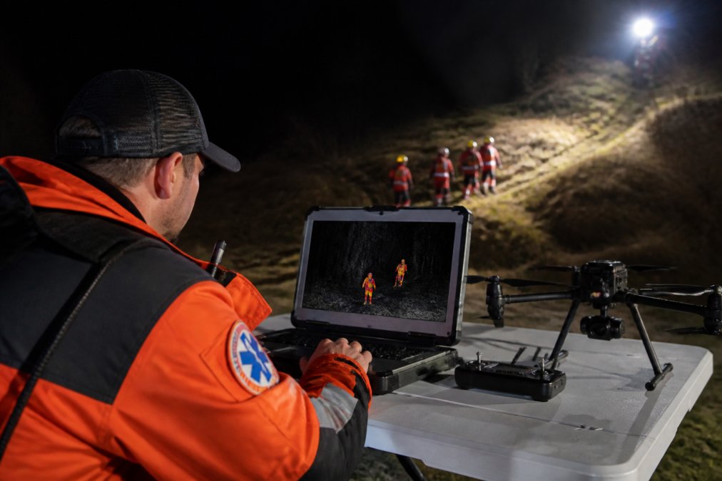
Thermal drone imaging detects infrared radiation emitted by objects and people, converting invisible heat signatures into visible thermal maps that guide emergency response teams through low-light and zero-visibility conditions. This technology has fundamentally changed how SAR operations locate missing persons, especially in darkness, fog, or dense vegetation where traditional visual cameras fail.
At Gods Eye Drone, we deploy thermal imaging systems that capture radiometric data in real time, allowing operators to identify human heat signatures from hundreds of feet in the air. The core advantage is speed: what might take ground teams hours to search manually can be scanned aerially in minutes, dramatically improving rescue outcomes when every second counts.
Radiometric Thermal Sensors and Heat Signature Detection
Radiometric thermal sensors measure the actual temperature of objects by detecting long-wave infrared radiation. Unlike standard thermal cameras that show only relative temperature differences, radiometric sensors provide calibrated temperature data at every pixel, enabling operators to distinguish between a human body (roughly 98 degrees Fahrenheit) and surrounding environmental heat sources like warm rocks or vehicles.
Heat signature detection relies on thermal contrast, the temperature difference between a person and their surroundings. A missing hiker in a cold forest presents a strong thermal signature because the body radiates warmth. However, this contrast diminishes in warmer environments, such as urban areas at midday where pavement and buildings retain heat. Experienced SAR operators adjust search patterns accordingly, focusing thermal imaging during cooler hours when human heat signatures stand out most clearly.
The sensor fusion approach combines thermal data with visual camera feeds simultaneously, providing operators with context that neither sensor alone can deliver. A thermal image might show a heat signature, but the visual feed confirms whether it's a person, animal, or equipment. This dual-layer verification reduces false positives and accelerates decision-making during critical rescue operations.
Thermal Resolution, NETD, and Sensor Fusion
Thermal resolution is measured in pixels and determines image detail. A 640×512 resolution sensor provides over 320,000 pixels, allowing operators to distinguish smaller objects and confirm targets from greater distances. For SAR applications, higher resolution enables identification of human figures from farther away, which is critical when drones must maintain safe altitude and distance.
NETD (Noise Equivalent Temperature Difference) measures thermal sensitivity, how small a temperature difference the sensor can detect. An NETD of 50 millikelvin means the camera can distinguish objects that differ by just 0.05 degrees Celsius. For SAR missions, sensors with NETD below 100 millikelvin provide the thermal sensitivity needed to locate humans reliably, even when thermal contrast is minimal.
Sensor fusion integrates thermal, visual, and sometimes multispectral data streams into a unified operational picture. A thermal drone equipped with sensor fusion displays both the infrared feed and high-definition visual imagery simultaneously, allowing operators to correlate thermal anomalies with visible landmarks. When a thermal signature appears near a riverbank, the visual feed confirms whether it's a person or debris, accelerating confirmation and reducing response time.
Key Features to Look for in the Best Thermal Drone for Search and Rescue
The best thermal drone for search and rescue combines thermal imaging capability with reliable flight performance, rapid deployment characteristics, and operator-friendly controls. Understanding which features matter most for your SAR mission prevents costly mistakes.
Thermal Sensitivity and Night Operations
Thermal sensitivity directly impacts your ability to locate humans in darkness, fog, and dense vegetation. Look for sensors with NETD specifications below 100 millikelvin and thermal resolution of at least 640×512 pixels for reliable human detection.
Night operations require stable flight control systems that maintain precise positioning in darkness without relying on visual references. Professional SAR drones use inertial measurement units (IMUs) and redundant positioning systems to maintain stability even when thermal imaging is the only sensor providing environmental awareness. Low-light visual cameras (separate from thermal) also matter, providing confirmation and context while thermal imaging locates targets.
Flight Endurance and Rapid Deployment
Flight endurance determines how long your drone can search before returning to recharge. Most professional thermal drones provide 20-35 minutes of flight time, translating to roughly 15-25 minutes of productive search time after accounting for climb, descent, and return-to-base margins. A drone with 30 minutes of endurance can cover more ground than one with 15 minutes, reducing battery swaps and extending your operational window.
Rapid deployment is equally critical. Look for systems that achieve flight-ready status in under 5 minutes, including quick-swap batteries and pre-configured flight parameters. Battery technology matters too, professional SAR drones use batteries rated for extended temperature ranges and include heating systems to maintain performance in cold climates.
Payload Capacity and Zoom Capabilities
Payload capacity determines what additional sensors you can carry alongside the thermal camera. A drone with adequate payload capacity, typically 500 grams or more beyond the thermal camera, provides operational flexibility for high-resolution visual cameras, spotlights, or speaker systems.
Zoom capabilities extend your effective search range. Thermal drones with 2-5x zoom can identify human heat signatures from greater distances, reducing the number of sorties needed to cover a search area. Professional SAR drones use three-axis gimbals with active stabilization, keeping the thermal image steady even during wind or aggressive maneuvering.
FAA Part 107 Requirements for SAR Drone Operations
Operating a thermal drone for search and rescue falls under FAA Part 107 regulations, which establish the legal framework for commercial and public safety drone operations. Compliance is not optional; violations carry significant penalties and can compromise evidence or liability in rescue scenarios.
Public Safety Waivers and Emergency Response Authority
FAA Part 107 imposes strict limitations: flights must stay below 400 feet altitude, within visual line of sight (VLOS) of the operator, and during daylight hours only. These restrictions make traditional SAR operations impossible, you cannot search effectively at 400 feet in darkness or maintain visual line of sight over a multi-acre search area.
Public safety agencies can petition the FAA for waivers that exempt them from specific Part 107 restrictions. A SAR waiver typically permits operations beyond visual line of sight (BVLOS), at night, and at altitudes above 400 feet when necessary for emergency response. The waiver process typically takes 60-90 days and requires detailed documentation of operational procedures. SAR agencies should initiate waiver requests well before they're needed, not during an active emergency. Gods Eye Drone's certified pilots maintain current FAA Part 107 certifications and work with emergency response agencies to support waiver applications and operational coordination.
Data Privacy and Evidence Handling
Thermal imagery captured during SAR operations constitutes potential evidence and may be subject to public records requests or legal discovery. Establish clear protocols for data handling, storage, and retention before flights occur. Document the chain of custody for all thermal imagery, including timestamps, flight parameters, and operator identification.
When thermal imagery is used in criminal investigations or civil litigation, admissibility depends on proper documentation and handling. Ensure that thermal drone operators understand the legal implications of the data they capture and maintain meticulous records supporting the integrity and accuracy of thermal images.
Drone Search and Rescue Tactics for Zero-Visibility Conditions
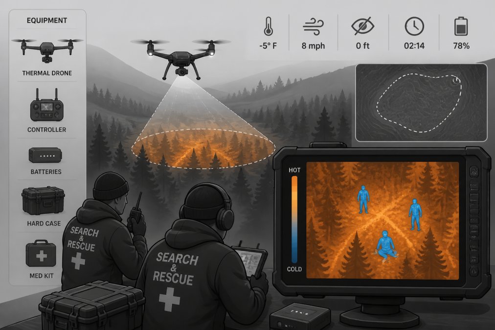
Zero-visibility conditions, complete darkness, dense fog, or heavy precipitation, are where thermal drone imaging for search and rescue proves most valuable. Visual search becomes impossible, but thermal imaging continues to detect human heat signatures.
Thermal Mapping and Search Patterns
Thermal mapping involves creating a systematic visual record of thermal data across the search area, building a composite picture of heat signatures and environmental thermal patterns. Structured thermal mapping follows predetermined flight paths that ensure complete coverage and prevent repeated scanning.
Search patterns depend on terrain and search area size. For small, defined areas (under 50 acres), a grid pattern, flying parallel lines with consistent spacing, ensures thorough coverage. For larger areas or complex terrain, expanding square patterns or spiral patterns may be more efficient. Environmental thermal patterns matter significantly: warm water bodies, dark rocks, and animal groups all produce thermal signatures that can be mistaken for humans. Experienced SAR operators learn to recognize false positives by analyzing thermal signature characteristics: human thermal signatures typically show consistent heat distribution over roughly 2-3 square meters, whereas animal signatures are smaller and often moving.
AI-Powered Object Recognition and Human Body Detection
Artificial intelligence systems trained on thousands of thermal images can detect human figures automatically, flagging potential targets for operator confirmation. AI-powered thermal analysis reduces operator fatigue during long search missions and accelerates target identification.
However, AI detection is not perfect. False positives occur in complex thermal environments, and false negatives happen when thermal contrast is minimal. The most effective approach combines AI automation with human judgment: let the AI system flag potential targets automatically, then have experienced operators review each candidate using visual imagery, thermal signature characteristics, and contextual knowledge of the search area.
Nighttime and Low-Visibility Operations
Nighttime rescue operations present unique challenges: darkness eliminates visual references for flight control, weather deteriorates, and operator fatigue increases. Thermal drone imaging becomes essential precisely because conventional search methods fail completely in these conditions.
Thermal imaging performs exceptionally well at night because the temperature contrast between humans and cool night air is often optimal. A person wearing typical clothing maintains a surface temperature around 85-95 degrees Fahrenheit while the surrounding air and ground cool to 40-60 degrees Fahrenheit, creating strong thermal signatures.
Nighttime operations demand additional safety measures. Drones must carry anti-collision lighting visible to manned aircraft. Operators need illuminated control stations and clear communication protocols with other emergency responders. Establish weather monitoring procedures and abort criteria before launching nighttime flights. Low-visibility operations, fog, rain, snow, degrade visual camera performance but often have minimal impact on thermal imaging. Fog is transparent to infrared radiation, making thermal drones invaluable during foggy rescue operations when ground teams cannot navigate safely.
Thermal Image Interpretation and Operator Training
Interpreting thermal imagery is a learned skill that separates effective SAR operations from ineffective ones. A thermal image showing a heat signature doesn't automatically mean you've found your target; it could be an animal, vehicle, or environmental anomaly. Training operators to read thermal data accurately is essential.
Thermal image interpretation training covers signature analysis, environmental context, and false positive recognition. Operators learn to identify characteristic thermal patterns of humans versus animals and to understand how terrain, vegetation, time of day, and weather conditions influence thermal contrast. This training typically requires 20-40 hours of structured instruction combined with practical field experience.
Human thermal signatures typically show consistent heat distribution over 1-3 square meters, temperature roughly 20-40 degrees Fahrenheit above ambient, roughly symmetrical shape when viewed from above, and stable signature over multiple image frames. Animal signatures differ: smaller area, often moving, less consistent temperature distribution, and different geometric patterns. A trained operator can distinguish these signatures within seconds, accelerating decision-making during critical rescue moments.
Maintenance, Calibration, and Mission Readiness
Thermal drones require more maintenance than visual-only systems because thermal sensors are sensitive instruments that degrade if not properly maintained. Establish a maintenance schedule that includes thermal sensor calibration, gimbal inspection, battery health checks, and firmware updates.
Thermal sensor calibration involves comparing the sensor's temperature readings against known reference sources. Professional thermal drones include built-in calibration routines that should be performed regularly, typically before every major mission or at least monthly during active use. Gimbal maintenance ensures smooth, stable thermal imagery; even minor gimbal degradation produces jittery imagery that strains operator focus. Battery management is critical for reliability: rotate batteries regularly, monitor capacity, and retire batteries that drop below 85% of rated capacity. For SAR operations, maintain spare batteries in ready condition so you can launch multiple sorties without delay.
Thermal drone imaging for search and rescue has become indispensable for emergency response teams operating in darkness, fog, and dense vegetation. The combination of radiometric thermal sensors, rapid deployment systems, and trained operators creates capabilities that ground teams simply cannot match. When a missing person's survival depends on speed and accuracy, thermal drones deliver results that save lives. Gods Eye Drone's thermal systems, built on advanced FLIR equipment and operated by certified pilots, provide the aerial environmental intelligence your SAR team needs to execute successful rescue operations. Contact Gods Eye Drone today to discuss how thermal imaging can enhance your emergency response capabilities and improve outcomes for your community.
Frequently Asked Questions
What makes thermal drone imaging effective for nighttime search and rescue operations?
Thermal imaging detects heat signatures from human bodies even in complete darkness or heavy fog, where visual cameras fail. Radiometric thermal sensors capture infrared radiation emitted by warm objects, allowing operators to locate missing persons regardless of lighting conditions. This capability transforms zero-visibility scenarios into actionable search patterns, dramatically reducing response time in critical emergencies.
Do I need a Part 107 license to operate a thermal drone for search and rescue?
Yes, operators must hold an FAA Part 107 certificate to legally fly any drone, including thermal systems. However, public safety agencies and emergency response teams can request a waiver from the FAA to operate beyond standard Part 107 limitations during active SAR missions. These waivers allow operations at night, beyond visual line of sight, and in restricted airspace when lives are at immediate risk.
What thermal resolution and NETD specifications should a SAR drone have?
For effective human detection in search and rescue, thermal drones should have a resolution of at least 320x256 pixels with a NETD (noise equivalent temperature difference) of 50 millikelvin or better. Lower NETD values mean greater thermal sensitivity, which improves the ability to detect subtle heat differences. Higher resolution allows operators to distinguish individual heat signatures in dense vegetation or complex terrain, critical for confirming targets.
What is the typical flight endurance needed for SAR thermal drone missions?
Most effective SAR thermal drones maintain 20-30 minutes of flight time, allowing operators to search large areas without frequent battery changes. Longer endurance reduces the need for multiple aircraft and enables thorough thermal mapping of search zones. Battery life depends on payload weight, environmental conditions, and flight speed; rapid deployment scenarios often require drones that launch within minutes of activation.
How does thermal imaging handle environmental interference in search and rescue?
Thermal contrast, the temperature difference between a target and surroundings, determines detection success. Challenges include thermal emissivity variations in different materials, water absorption of infrared, and thermal clutter from warm objects like vehicles or structures. Experienced operators compensate by understanding how terrain, vegetation, and weather affect thermal signatures, using geotagging and telemetry data to correlate thermal anomalies with ground truth.
What training is required to interpret thermal images during SAR operations?
Operators need specialized training to distinguish human heat signatures from false positives like animals, vehicles, or thermal reflections. Thermal image interpretation requires understanding how different materials emit heat, how weather affects contrast, and how to read pixel pitch and temperature gradients. Many agencies pair certified drone pilots with thermal specialists or SAR coordinators to validate detections before committing ground teams.
This article was written using GrandRanker