 ultimate-guide
Drone Videography for Real Estate: A 2026 Guide
Table of Contents
- Why Drone Videography Matters for Real Estate Marketing
- Real Estate Drone Photography Pricing: What to Expect
- Best Practices for Real Estate Drone Videography
- FAA Part 107 Certified Drone Pilots: Legal Requirements for Realtors
- How Drone Footage Integrates with MLS and Social Media
- ROI Analysis: Does Drone Videography Pay Off?
- Commercial vs. Residential Drone Services
- Frequently Asked Questions
Last Updated: September 23, 2026
Why Drone Videography Matters for Real Estate Marketing
Drone videography real estate transforms how properties sell from an aerial perspective. When potential buyers see a home from above, they understand the lot size, neighborhood density, proximity to amenities, and overall property context in ways ground-level photos cannot convey. Drone videography for real estate has become essential for agents competing in today's market because it directly influences listing engagement and reduces time on market.
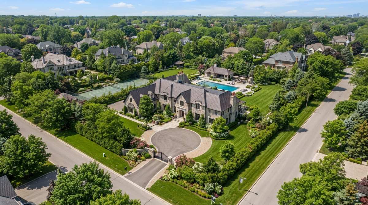
Visual storytelling is now essential. Properties with drone footage capture attention faster and communicate premium positioning, creating emotional connection that still photography cannot match.
Professional-grade videography separates listings that sell quickly from those that languish, paying dividends through faster sales cycles and higher perceived property value.
Real Estate Drone Photography Pricing: What to Expect
Understanding typical pricing tiers helps you budget accurately and compare providers.
Pricing Factors and Typical Ranges
Pricing depends on project scope, property size, turnaround time, and deliverables (photos, video, 3D tours).
Commercial properties and large acreage command higher fees. Multi-acre development sites may exceed typical project costs.
Calculating Your ROI
Calculate ROI by comparing holding costs to time saved. For a property, daily carrying costs can be significant. Reducing time-on-market can lead to substantial savings, often exceeding the cost of professional drone videography.
Luxury properties ($750K+) see stronger ROI due to higher carrying costs and smaller buyer pools. Waterfront homes, large acreage, and distinctive properties show measurable engagement lift with drone footage.
What's Included vs. What Costs Extra
Standard packages include edited video, delivery in multiple formats, and basic music. Common add-ons include Matterport integration, still photography, expedited turnaround, thermal imaging, and cinematic grading.
Confirm you own the final edited video for unlimited future use. Some providers retain licensing rights, limiting repurposing.
Best Practices for Real Estate Drone Videography
Planning Your Aerial Shots
Scout the property to identify strongest angles and optimal lighting. Professional pilots map establishing wide shots, then closer passes highlighting specific features. Logical visual narrative keeps viewers engaged.
Certified pilots understand that waterfront homes, suburban residences, and commercial properties each demand different visual strategies. This planning discipline separates professional results from amateur footage.
Weather and Seasonal Considerations
Weather directly impacts quality. Golden hour (sunrise/sunset) provides warm, directional light. Avoid overcast days and harsh midday sun.
Spring and fall offer crisp air and clear skies. Summer brings haze; winter reduces flight time due to cold.
Professional operators reschedule for optimal conditions rather than deliver subpar footage.
Post-Production and Delivery
Post-production includes color grading, stabilization, music, and transitions. Most services deliver in multiple formats: full-length video, social media cuts, and still frames.
Confirm file formats match your MLS, website, and social platforms. Clarify ownership, you should own footage outright for unlimited use.
FAA Part 107 Certified Drone Pilots: Legal Requirements for Realtors
Commercial drone operation requires FAA Part 107 certification. This is not optional, and the distinction between licensed and unlicensed operators has serious legal and financial implications for real estate professionals.
Why Part 107 Certification Matters for Your Liability
Under Federal Aviation Regulation Part 107, any person operating a drone for compensation, including real estate photography, must hold a valid Remote Pilot Certificate issued by the FAA. The regulation applies regardless of whether the drone operator is a dedicated service provider or an agent flying their own equipment.
The liability exposure is significant. If an unlicensed operator damages property, injures a person, or violates airspace restrictions while filming your listing, you as the hiring agent or broker may face joint liability. Insurance carriers often deny claims if the operator lacked required certification. The FAA itself can fine unlicensed operators for commercial operations, but that fine does not protect you from civil lawsuits by injured parties or property owners.
More subtly, hiring an unlicensed operator exposes your brokerage to regulatory scrutiny. State real estate commissions increasingly audit marketing practices, and using uncertified drone services can trigger compliance violations separate from FAA penalties.
How to Verify Part 107 Credentials
Do not accept verbal assurances. Verify credentials directly:
-
Request the Remote Pilot Certificate number. A valid Part 107 certificate is a physical credential issued by the FAA with a unique number. Any legitimate operator should provide this without hesitation.
-
Cross-check on the FAA Airmen Certification Database. Visit the FAA's online database (faa.gov/pilots) and search by certificate number or pilot name. The database is public and updated in real time. A current certificate will show the pilot's name, certificate type (Remote Pilot), and issue/expiration dates.
-
Confirm liability insurance. Part 107 operators should carry commercial drone liability insurance. Ask for a certificate of insurance naming your brokerage as an additional insured. This protects you if an incident occurs during the shoot.
-
Ask about recency and currency. Part 107 certification does not expire, but the knowledge test must be passed within the previous 24 calendar months. Operators who passed the test five years ago but have not retested are technically non-compliant. Reputable providers retake the test regularly to stay current with regulation changes.
What Part 107 Certification Actually Requires
To hold a Remote Pilot Certificate, an operator must:
- Pass the FAA Part 107 knowledge test
- Pass a TSA background check
- Understand airspace rules, weather limitations, and emergency procedures
- Maintain line-of-sight operation (visual contact with the drone at all times)
- Observe a 400-foot altitude ceiling
- Avoid flying over people, moving vehicles, or buildings
- Operate only during daylight or civil twilight
- Conduct a pre-flight safety inspection
These rules exist because drones pose genuine safety risks. A drone falling from 400 feet can cause serious injury. Unauthorized airspace incursions can interfere with manned aircraft. Part 107 compliance is not bureaucratic overhead, it is a baseline safety and liability framework.
Red Flags When Evaluating Drone Service Providers
- Operator cannot or will not provide certificate number
- Certificate number does not appear in FAA database
- Operator claims to be "licensed" but cannot specify Part 107
- No liability insurance or unwillingness to name you as additional insured
- Operator offers same-day turnaround on complex shoots (suggests rushing and corner-cutting)
- Operator has no portfolio or references from other real estate professionals
The Institutional Advantage
Established drone service providers maintain compliance as institutional practice. They carry errors-and-omissions insurance, maintain current certifications for all pilots, conduct regular safety audits, and document every flight in compliance logs. This overhead costs money, which is why professional services cost more than unlicensed operators. But that cost is your protection.
How Drone Footage Integrates with MLS and Social Media
Drone videography real estate listings perform better across all distribution channels. MLS systems now prominently feature video content, and listings with aerial footage receive more clicks and showings (Drones). The integration is seamless: most MLS platforms accept video embeds or links directly to hosted content.
Social media amplification extends reach beyond traditional MLS exposure. Instagram and Facebook videos with aerial property views generate higher engagement than static photos. TikTok has become an unexpected channel for real estate content, particularly short drone clips showing the property's relationship to neighborhood amenities.
The key is formatting. Vertical video for Instagram Stories and TikTok, horizontal for Facebook and YouTube, and square for thumbnail compatibility. Professional providers deliver multiple cuts optimized for each platform, eliminating the work of reformatting yourself.
Matterport 3D virtual tours integrate powerfully with drone footage. A viewer sees the aerial context first, then navigates the interior with 360-degree imagery. This sequential storytelling, outside to inside, mirrors how buyers actually experience properties and increases engagement time significantly.
ROI Analysis: Does Drone Videography Pay Off?
The ROI case for drone videography depends on property type and market position. For luxury residential properties, waterfront homes, and large acreage, the impact is measurable: faster sales, higher perceived value, and reduced marketing spend. For modest homes in competitive markets, the benefit exists but is less dramatic.
Calculate your ROI simply: What does it cost to hold a property for an additional 21 days? Mortgage, property taxes, utilities, and agent time add up quickly. If drone footage reduces your average days-on-market, the videography investment can pay for itself immediately.
For commercial properties and development sites, drone footage supports site inspections, progress documentation, and investor presentations.
Commercial vs. Residential Drone Services
Commercial and residential drone work require different expertise. Residential real estate videography emphasizes property appeal and lifestyle marketing. Commercial services focus on documentation, scale, and technical precision.
Frequently Asked Questions
Do I need a licensed drone pilot for real estate drone footage?
Yes. Under FAA Part 107, any commercial drone operation, including real estate photography, requires a licensed pilot holding a Remote Pilot Certificate. This ensures compliance with federal regulations, proper flight planning, and liability coverage. Hiring a certified operator protects your business and guarantees professional-quality aerial videography that meets industry standards.
How much do realtors typically pay for professional drone videography?
Pricing depends on project scope, property size, turnaround time, and deliverables (photos, video, 3D tours). Factors like same-day turnaround or specialized services increase cost. Contact Gods Eye Drone for a custom quote based on your specific listing needs and timeline.
What is the typical turnaround time for drone videography deliverables?
Standard turnaround for edited footage and high-resolution imagery depends on project complexity and post-production requirements. Rush delivery options are available. Discuss your timeline when booking to confirm delivery expectations.
Can drone videos actually increase real estate listing engagement and sales?
Yes. Aerial videography and cinematic property tours significantly boost listing engagement, properties with drone footage receive more views and inquiries. Aerial perspective showcases property topography, lot size, neighborhood context, and surrounding amenities that static photos cannot capture, making listings more compelling to buyers.