 how-to
How Thermal Imaging Drones Assist Rescue: A 2026 Guide
Table of Contents
- How Thermal Imaging Drones Detect Heat Signatures in Rescue Operations
- Real-Time Video Feed and Data Transmission to Ground Teams
- Best Thermal Drone for Search and Rescue: Key Specifications
- Drone Search and Rescue Best Practices for Emergency Response
- Limitations of Thermal Drones in Rescue: What You Need to Know
- Post-Processing Thermal Data and Image Analysis
- Thermal Imaging Drones in Specific Rescue Scenarios
- Data Privacy and Legal Considerations for Thermal Drone Operations
- Frequently Asked Questions
Last Updated: August 17, 2026
How Thermal Imaging Drones Detect Heat Signatures in Rescue Operations
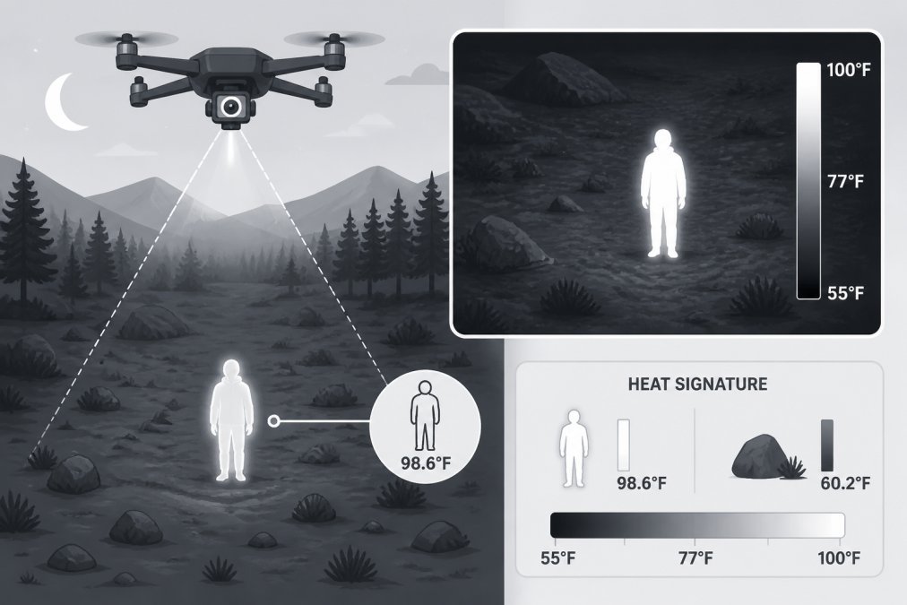
Thermal imaging drones detect heat signatures by capturing infrared radiation emitted from objects and people, converting that invisible energy into visible video feeds that ground teams can analyze in real time. A person generates body heat around 98 degrees Fahrenheit, which a drone's radiometric thermal camera captures and translates into pixel data. The thermal contrast between a warm human body and a cold landscape creates a distinctive heat signature, making rescue operations possible when visibility is near zero.
Infrared Radiation and Thermal Contrast Detection
Infrared radiation exists just beyond the visible light spectrum, with wavelengths between 7 and 14 micrometers for most rescue-grade thermal cameras. The key advantage in rescue work is that infrared travels through conditions that block visible light: darkness, fog, smoke, and light rain.
Thermal contrast, the temperature difference between a target and its background, is critical. A living human body creates strong thermal contrast against cold ground, water, or rock. In a snowy avalanche field, a buried person's body heat creates a visible signature against the frozen landscape. Effectiveness depends on several factors: nighttime searches often show better contrast as ambient temperatures drop, while rain, heavy fog, and extreme cold can reduce thermal contrast. A person wearing heavy insulation retains more heat and shows a stronger signature.
Thermal Sensor Sensitivity and Pixel Resolution
Thermal sensitivity, measured in milliKelvins (mK), determines how well a camera can distinguish small temperature differences. For rescue operations, sensitivity typically ranges from 40 to 100 mK depending on the drone and camera model. Pixel resolution in thermal imaging works differently than visible-light photography; a thermal camera with 320 × 256 pixel resolution provides adequate detail for identifying humans at rescue distances, while higher resolutions like 640 × 512 pixels offer better clarity from greater altitudes.
Radiometric capabilities matter for post-analysis. Radiometric data means the camera records actual temperature values for each pixel, allowing rescue teams to determine whether a heat signature is consistent with a living human versus residual heat from a fire or warm object. Gods Eye Drone utilizes state-of-the-art FLIR equipment that captures precise radiometric data, enabling detailed thermal analysis for search and rescue teams.
Real-Time Video Feed and Data Transmission to Ground Teams
Real-time video transmission is the operational backbone of thermal drone rescue work. Most rescue-grade thermal drones transmit video via secure digital links at ranges up to 3 miles, with effective operational range typically 1-2 miles depending on terrain and interference. The ground control station receives the thermal video feed with minimal latency, usually under 500 milliseconds, allowing ground teams to direct the drone and adjust altitude based on what they're seeing.
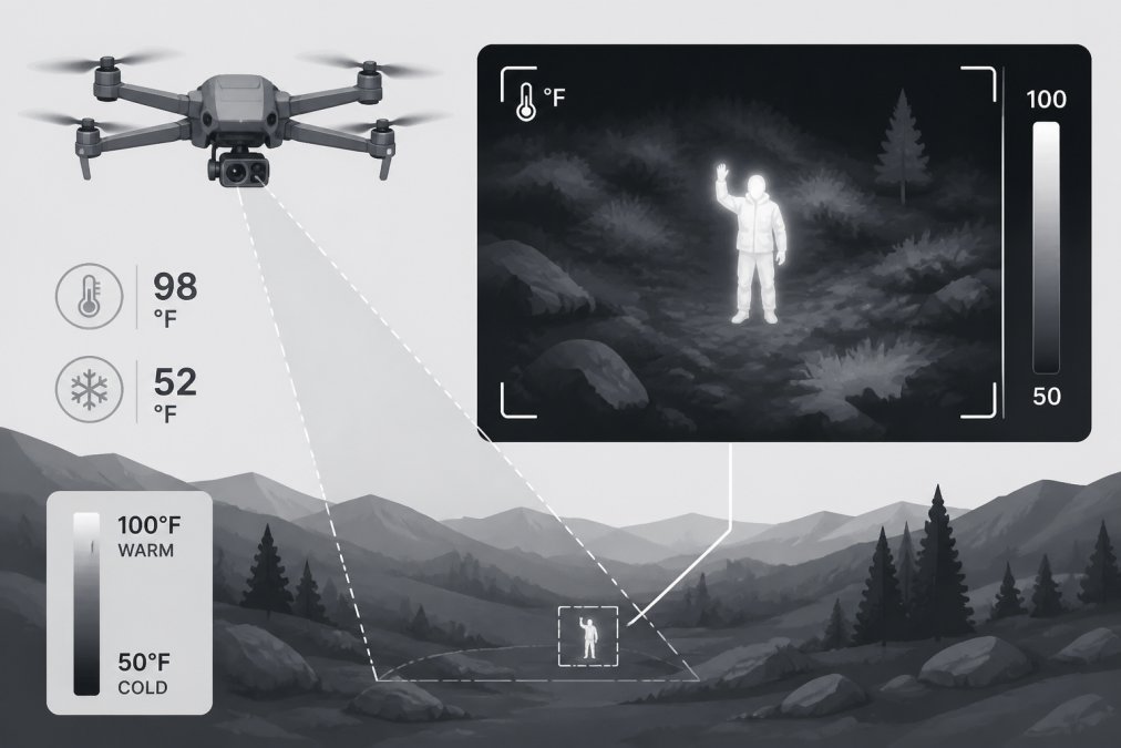
Ground teams use the real-time feed to make immediate decisions: Is this heat signature a person or a false alarm? Should we send ground crews to this location? The speed of this decision loop directly impacts rescue success. A thermal imaging drone that provides clear, real-time radiometric data allows incident commanders to allocate resources efficiently and prioritize high-probability target areas.
Best Thermal Drone for Search and Rescue: Key Specifications
Selecting the right thermal drone for search and rescue requires evaluating flight endurance, payload capacity, thermal sensor quality, and ease of deployment under emergency conditions.
Flight Endurance and Payload Capacity
Flight endurance directly impacts search area coverage. Most rescue operations require 20-30 minutes of continuous flight to search a specific area thoroughly. Drones with 30-40 minute endurance allow operators to conduct initial surveys without excessive delays. Battery performance is critical in rescue scenarios; a drone rated for 30 minutes at 70 degrees Fahrenheit might deliver only 18-20 minutes in 30-degree conditions. Rescue teams must account for this degradation and carry spare batteries to maintain continuous search capability.
Radiometric Data and Ground Control Station Integration
Radiometric thermal data transforms raw thermal video into actionable intelligence. The best systems allow operators to pan, tilt, and zoom the thermal camera while monitoring live radiometric data overlays, with temperature scales, isotherm highlighting, and measurement tools that help operators quickly assess whether a heat signature matches expected characteristics of a missing person. Integration with mapping software allows thermal data to be georeferenced, creating a thermal map of the search area that can be shared with ground teams. Gods Eye Drone's certified pilots are trained to operate advanced thermal imaging systems and integrate thermal data with mission planning tools, ensuring rescue teams receive both raw footage and processed intelligence.
Drone Search and Rescue Best Practices for Emergency Response
Effective thermal drone deployment requires disciplined mission planning and coordination with incident commanders.
Mission Planning and Tactical Deployment
Pre-flight briefings establish clear objectives, search areas, and communication protocols. Incident commanders define the search area and specify what the thermal drone is looking for. Altitude selection affects both thermal image quality and search efficiency; flying at 300-400 feet provides good thermal contrast and reasonable pixel resolution for detecting humans. Search patterns depend on terrain: grid searches work well for open areas, contour searches follow terrain features in mountainous regions, and route searches follow likely travel paths.
Communication between the drone operator and incident command is continuous. The operator reports thermal signatures, their location, temperature characteristics, and confidence level. False alarms are common; thermal signatures from wildlife, warm rocks, or campfires can mimic human heat signatures. Discipline in reporting prevents wasted ground resources.
Pilot Training and Certification Requirements
Operating a thermal imaging drone in rescue operations requires Federal Aviation Administration Part 107 certification as the baseline requirement for commercial drone operations. Beyond Part 107, rescue-grade operations demand additional training in thermal image interpretation, understanding how weather, terrain, and target characteristics affect thermal signatures. Gods Eye Drone's certified pilots have completed advanced thermal imaging training and maintain current certifications, ensuring they can deliver reliable support during critical rescue missions. Recurrent training is important; pilots should conduct quarterly training flights and participate in simulated rescue scenarios to maintain proficiency.
Limitations of Thermal Drones in Rescue: What You Need to Know
Thermal imaging drones are powerful tools, but they have real constraints that rescue teams must understand and plan around.
Environmental Constraints and Battery Life
Battery life is the most immediate constraint. A drone with 30-minute endurance can search roughly a 1-2 square mile area per flight. In winter conditions, battery performance degrades 30-40%, reducing effective endurance to 18-20 minutes. Weather significantly impacts thermal drone operations; high winds above 20-25 mph make small drones unstable and dangerous, while rain and heavy fog reduce thermal contrast and degrade image quality. Environmental temperature affects thermal contrast; in warm climates, ambient temperature rises and thermal contrast between humans and surroundings decreases, reducing detection range.
Dense Vegetation and Weather-Related Challenges
Dense forest canopy blocks thermal imaging almost completely. Trees absorb and scatter infrared radiation, preventing thermal cameras from seeing through to the ground beneath. Thermal drones excel in open terrain but struggle in dense woods. Water creates challenges for thermal imaging; open water absorbs infrared radiation and appears dark on thermal displays. Weather-related challenges compound operational difficulty: wind limits flight safety and increases power consumption, rain attenuates infrared signals and reduces thermal contrast, and fog and mist scatter infrared radiation, degrading image quality.
Post-Processing Thermal Data and Image Analysis
Raw thermal video from a rescue mission is just the beginning. Thermal analysts review footage frame by frame, identifying heat signatures and correlating them with geographic location. Radiometric data allows analysts to measure temperature values and assess whether signatures match expected characteristics; a human body maintains approximately 98 degrees Fahrenheit even in cold conditions, while animals and warm objects show different thermal characteristics. Thermal image enhancement techniques improve visibility of subtle signatures through histogram equalization and isotherm overlays. Geospatial analysis ties thermal data to location, creating a thermal map showing where heat signatures were detected and integrating with satellite imagery or topographic maps.
Thermal Imaging Drones in Specific Rescue Scenarios
Thermal imaging drones prove most valuable in specific situations where their capabilities directly address operational challenges.
Avalanche Search and Low-Visibility Operations
Avalanche rescue represents one of the most critical applications for thermal imaging drones. When an avalanche buries people under snow, time is the enemy. Thermal imaging drones can scan the debris field rapidly, identifying any heat signatures protruding through the snow surface. A person's head or hand exposed to the surface creates a detectable thermal signature. Low-visibility conditions, fog, darkness, and heavy rain, are precisely where thermal imaging drones provide maximum advantage, allowing search of an avalanche debris field in minutes rather than hours.
Disaster Response and Remote Terrain Access
Large-scale disasters create chaotic environments where rescue teams need rapid situational awareness. Thermal imaging drones provide immediate intelligence about damaged areas, identifying heat signatures of survivors in collapsed buildings or isolated locations. Remote terrain access is another critical application; mountainous regions and rugged wilderness areas make ground access slow and dangerous, while thermal drones can reach these areas in minutes. Thermal drones support rescue operations in water environments by rapidly scanning coastlines and riverbanks for heat signatures.
Data Privacy and Legal Considerations for Thermal Drone Operations
Thermal imaging technology raises legitimate privacy concerns. Federal law doesn't explicitly prohibit thermal imaging by private citizens or organizations, but constitutional protections against unreasonable search apply to law enforcement. Many states and municipalities have enacted specific regulations governing thermal imaging. Rescue organizations should verify local regulations before deploying thermal drones, especially in populated areas. Data handling procedures protect thermal imagery from misuse; raw thermal files contain sensitive information about building layouts and occupancy patterns. Secure storage, access controls, and defined retention periods prevent unauthorized use. Transparency with the public builds trust in thermal drone rescue operations.
Rescue operations in challenging environments demand tools that extend human capability beyond normal limits. Thermal imaging drones provide that extension, detecting heat signatures in darkness and poor visibility where conventional methods fail. Gods Eye Drone's veteran-led team understands the mission-critical nature of thermal drone support for search and rescue operations. Our certified pilots operate state-of-the-art FLIR thermal equipment and integrate seamlessly with incident command structures, delivering the aerial intelligence your emergency response teams depend on. When lives are at stake, precision and reliability aren't optional, they're essential. Book Now to discuss how thermal imaging drones can enhance your agency's rescue capabilities.
Frequently Asked Questions
How do thermal imaging drones detect humans in search and rescue?
Thermal imaging drones detect humans by capturing infrared radiation emitted by the body. The thermal camera identifies heat signatures that contrast with the surrounding environment. A person's body temperature typically appears as a bright spot against cooler terrain, making detection possible even in complete darkness or low-visibility conditions. Thermal sensor sensitivity determines how quickly and clearly the drone can identify these signatures across varying distances and environmental conditions.
What are the limitations of thermal drones in rescue operations?
Thermal drones face several operational constraints. Dense vegetation, water, and certain weather conditions reduce thermal contrast and detection capability. Battery life limits flight endurance, typically 20-30 minutes depending on payload capacity and environmental factors. Heavy rain, fog, and extreme cold can degrade sensor performance. Additionally, thermal imaging cannot penetrate solid objects, so victims under rubble or dense snowpack may not be detectable. Data transmission range and real-time video feed latency can also affect mission-critical decision-making during time-sensitive operations.
What is the best thermal drone for search and rescue operations?
The best thermal drone for search and rescue balances flight endurance, thermal sensor quality, and payload capacity. Key specifications include radiometric data capability for accurate temperature measurement, high pixel resolution for object detection, extended battery life for covering remote terrain, and seamless ground control station integration for real-time video feed to emergency response teams. Certified pilots familiar with SAR operations and aircraft capable of tactical deployment in challenging weather are equally important. Evaluate drones based on thermal sensitivity, mission-critical performance metrics, and compatibility with your team's existing emergency response protocols.
Can thermal drones operate effectively in extreme weather conditions?
Thermal drones have reduced effectiveness in extreme weather. Heavy rain, snow, and dense fog create thermal contrast issues that degrade image quality and object detection capability. Wind conditions affect flight stability and endurance. However, thermal imaging remains superior to visible-light cameras in low-light and night-time rescue scenarios. For disaster response and avalanche search operations, thermal drones often outperform traditional aerial surveillance despite weather challenges. The key is understanding your specific environmental constraints and planning missions during optimal conditions when possible, while recognizing that thermal technology still provides situational awareness when other methods fail.
This article was written using GrandRanker